
Map Explorer
Map 11. Quay Lane - Station Road
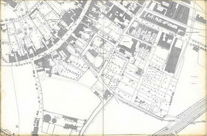
From Christopher Lane down to Quay Lane and across to Station Road. Pencil guidelines suggest that some of the gasworks buildings were added post 1887 but otherwise the map is as published. Note the large EDME maltings next to Barton’s Stour Valley Iron Works, now the site of Waitrose carpark, and the web of sidings and turntables which served the other commercial buildings to the east of Station Road. LXXIX.3.4
Sponsored by:

© Sudbury Museum Trust 2008