
Map Explorer
Map 2. Melford Road - The Wents
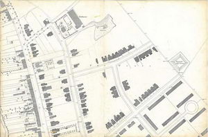
From Melford Road east up the valley slopes to the network of roads laid out in the late 19th century - Woodhall, Queens, Clarence, Stanley and York. Note the heavier, hand drawn additions added by the Borough Surveyor after 1885. The water pumping station on Woodhall Road (just off the map) and the building of the reservoir at the top of York Road made all this development possible. LXXII.15.14
Sponsored by:

© Sudbury Museum Trust 2008