
Map Explorer
Map 12. Cornard Road
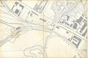
From Station Road across to the river and up to and beyond the Cornard Road. There are significant later hand-drawn additions in a heavier ink – many late Victorian/Edwardian villas lining Cornard Road, a new building associated with Oliver’s Brewery and Stephen Walters silk factory (erected c1890.) Note that where Ernest Doe’s now stands, a railway siding ran under the road into Allen and Boggis’s chalk pit opposite (now occupied by Lucas Drive.) LXXIX.3.5
Sponsored by:

© Sudbury Museum Trust 2008